This is one of the most spectacular hikes in the New Jersey-New York metropolitan area. Although it begins with a fairly strenuous 600-foot climb, the rest of the hike does not involve any major elevation changes. There are, however, many short, steep ups and downs, some of which require you to use your hands as well as your feet. The estimated time of four hours should allow you plenty of...
Hike Description:
This is one of the most spectacular hikes in the New Jersey-New York metropolitan area. Although it begins with a fairly strenuous 600-foot climb, the rest of the hike does not involve any major elevation changes. There are, however, many short, steep ups and downs, some of which require you to use your hands as well as your feet. The estimated time of four hours should allow you plenty of time to pause and enjoy the wonderful scenery that you'll encounter along the route.
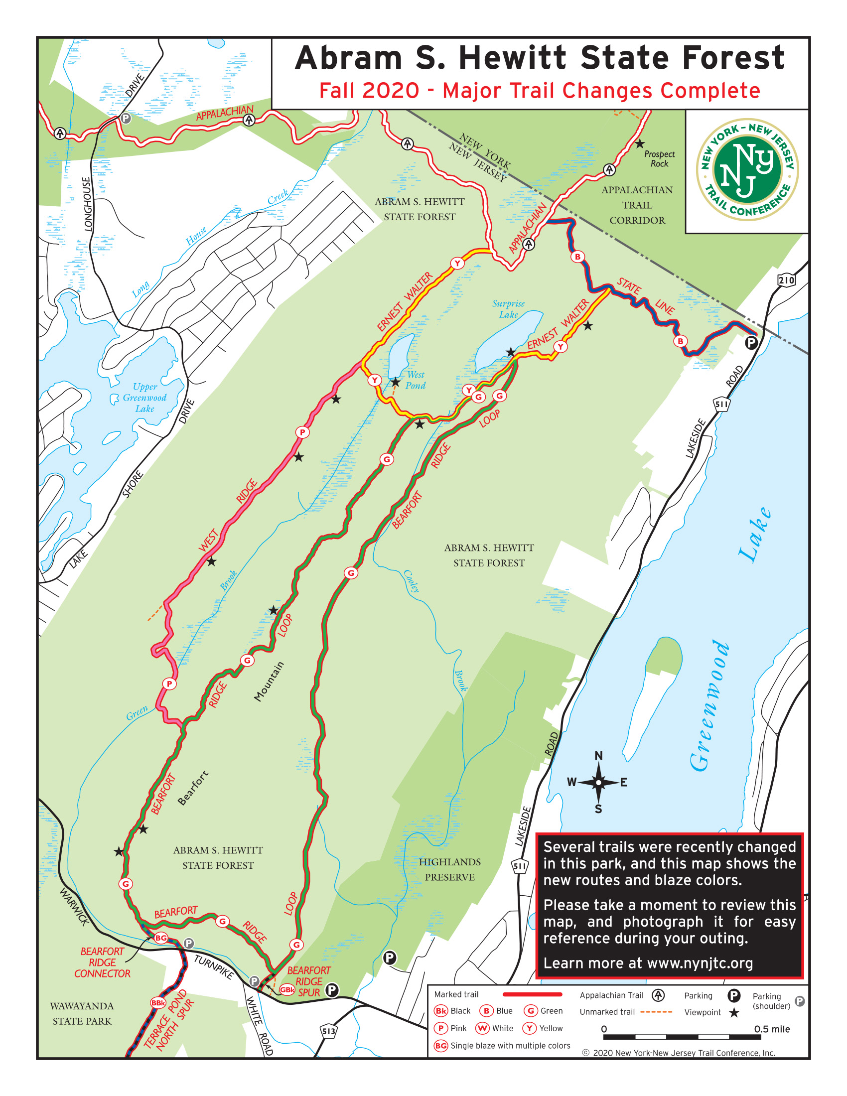
From the kiosk at the end of the parking area, bear left onto the blue-on-white-blazed State Line Trail, which follows a wide, rocky footpath up Bearfort Mountain. The ascent is moderate at first, and the trail soon levels off. With a private home visible ahead on the left, the trail turns right and soon begins to climb more steeply. Along the way, a switchback has been constructed by Trail Conference volunteers to ease the grade.
In about a mile, you’ll notice young hemlocks growing along the trail. Just ahead, you’ll reach an intersection with the yellow-blazed Ernest Walter Trail. Bear left and follow the yellow-blazed trail uphill. Soon, you begin to traverse a long, glacially-smoothed outcrop of Schunemunk Conglomerate “puddingstone” rock. This unusual reddish-matrix conglomerate rock – studded with pebbles of pink sandstone and white quartz – is characteristic of the Bearfort Ridge. As you climb along the rock outcrop, views open up over Greenwood Lake to the east.
Continue to the top of the outcrop, which offers a panoramic view over the six-mile-long lake, 650 vertical feet below. The hills of Sterling Forest are in the background and, on a clear day, you can see the Sterling Forest Fire Tower in the distance. You’ll want to spend some time here, taking in the magnificent view and resting from the steep climb.
When you’re ready to resume the hike, continue along the Ernest Walter Trail, which passes through an area studded with pitch pines and then comes out on another long conglomerate outcrop, with more views over Greenwood Lake. After traversing another area covered with pitch pines, the trail climbs steeply to a third long conglomerate outcrop, then bears right and descends through the woods to cross the outlet of a wetland to the right of the trail. A short distance beyond, it reaches the eastern shore of pristine, spring-fed Surprise Lake (just to the right of the trail). Again, you’ll want to stop here to experience the beauty of this wilderness lake. 
The yellow trail heads south from the lake, immediately reaching a junction with the green-blazed Bearfort Ridge Loop. You should bear right to continue along the Ernest Walter Trail, now coaligned with the Bearfort Ridge Loop. In a short distance, you’ll begin to pass through a dense rhododendron grove. In several places, the thick rhododendrons actually form a canopy over the trail!
After descending a little, the trail crosses Cooley Brook, the outlet of Surprise Lake, on rocks. This crossing may be difficult if the water is high. The trail now climbs to reach an east-facing viewpoint from a rock outcrop studded with pitch pines. The hills of Sterling Forest and the Wyanokie Plateau are directly ahead, with an arm of the Monksville Reservoir beyond. On a clear day, you can see the skyscrapers of Manhattan in the distance.
Here, the green-blazed Bearfort Ridge Trail leaves to the left, but you should continue along the yellow-blazed Ernest Walter Trail, which heads west, crossing many sharp ridges of the  mountain. This section of trail is particularly rugged, with many short but steep ups and downs. At the bottom of the second steep descent, you’ll come to a T-intersection. Turn right, following a black-star-on-yellow blaze on a tree, and continue for about 150 feet to a rock outcrop overlooking pristine West Pond. You’ll want to spend a little time at this special spot, enjoying the view.
When you’re ready to continue, retrace your steps to the trail junction and continue ahead, heading west along the Ernest Walter Trail. You’ll soon come to a third, very steep descent, at the base of which the trail crosses Green Brook, the outlet stream of West Pond, on rocks. The trail now proceeds through an attractive forest of hemlocks, pines and deciduous trees, with an understory of mountain laurel.
After some more ups and downs, you'll reach a junction with the pink-blazed West Ridge Trail, which begins on the left. Bear right at the junction to continue on the yellow-blazed Ernest Walter Trail, which now heads north, with views of West Pond through the trees to the right. This section of the trail, which is relatively level, goes across several long, narrow rock outcrops. Along the way, the trail crosses a small stream, the outlet of a wetland on the left. Just beyond, a short unmarked trail on the left leads to a rock outcrop that affords a view over the wetland. An unusual huge split boulder adds interest to this spot, which is another good place to take a break.
A little over half a mile from the junction with the West Ridge Trail, the Ernest Walter Trail turns right and descends to end at a junction with the white-blazed Appalachian Trail (A.T.). Turn right onto the Appalachian Trail, which almost immediately climbs a steep ledge. You’re now heading east, again crossing several sharp ridges. At a limited viewpoint to the east, from which the New York City skyline can be seen, the trail turns left and heads north (when there are no leaves on the trees, Surprise Lake is visible below).
After about a third of a mile on the A.T., the trail crosses an open rock ledge with pitch pines. The A.T. now descends a long, sloped rock and reaches a junction with the blue-on-white-blazed State Line Trail (the junction is marked by paint blazes on a rock). Turn right and follow the State Line Trail, which crosses several ridges. In about half a mile, the trail descends through hemlocks and mountain laurel to reach the junction with the yellow-blazed Ernest Walter Trail that you encountered earlier in the hike. Continue along the State Line Trail, which descends steadily, now retracing your steps to the parking area on Lakeside Road where the hike began.
Publication: Submitted by Daniel Chazin on 06/03/2005 updated/verified on 12/21/2023

This loop hike traverses the Bearfort Ridge, with its unusual puddingstone conglomerate rock and pitch pines growing out of bedrock, reaches a panoramic viewpoint over Greenwood Lake, goes through a rhododendron tunnel, and passes Surprise Lake and West Pond.
41.185735, -74.331571
Passaic Co., NJ
4 mi
4 hrs

Web Map: Abram S. Hewitt State Forest map
Avenza App Map: Northern New Jersey Highlands 152
Hike Checklist:
Whether you are going for a day hike or backpacking overnight, it is good practice to carry what we call The Hiking Essentials. These essentials will help you enjoy your outing more and will provide basic safety gear if needed. There may also be more essentials, depending on the season and your needs.
The Essentials
Hiking Shoes or Boots
Water - Two quarts per person is recommended in every season. Keep in mind that fluid loss is heightened in winter as well as summer. Don't put yourself in the position of having to end your hike early because you have run out of water.
Map - Know where you are and where you are going. Many of our hiking areas feature interconnecting network of trails. Use a waterproof/tear-resistant Tyvek Trail Conference map if available or enclose your map in a Ziplock plastic bag. If you have a mobile device, download Avenza’s free PDF Maps app and grab some GPS-enhanced Trail Conference maps (a backup Tyvek or paper version of the map is good to have just in case your batteries die or you don't have service). Check out some map-reading basics here.
Food - Snacks/lunch will keep you going as you burn energy walking or climbing. Nuts, seeds, and chocolate are favorites on the trail.
Sunscreen and insect repellent
Rain Gear and Extra Clothing - Rain happens. So does cold. Be prepared for changing weather. Avoid cotton--it traps water against your skin and is slow to dry. If you are wearing wet cotton and must return to your starting point, you risk getting chills that may lead to a dangerous hypothermia. Choose synthetic shirts, sweaters and/or vests and dress in layers for easy on and off.
Compass - A simple compass is all you need to orient you and your map to magnetic north.
Light - A flashlight or small, lightweight headlamp will be welcome gear if you find yourself still on the trail when darkness falls. Check the batteries before you start out and have extras in your pack.
First Aid Kit - Keep it simple, compact, and weatherproof. Know how to use the basic components.
Firestarter and Matches - In an emergency, you may need to keep yourself or someone else warm until help arrives. A firestarter (this could be as simple as leftover birthday candles that are kept inside a waterproof container) and matches (again, make sure to keep them in a waterproof container) could save a life.
Knife or Multi-tool - You may need to cut a piece of moleskin to put over a blister, repair a piece of broken equipment, or solve some other unexpected problem.
Emergency Numbers - Know the emergency numbers for the area you're going to and realize that in many locations--especially mountainous ones, your phone will not get reception.
Common Sense - Pay attention to your environment, your energy, and the condition of your companions. Has the weather turned rainy? Is daylight fading? Did you drink all your water? Did your companion fail to bring rain gear? Are you getting tired? Keep in mind that until you turn around you are (typically) only half-way to completing your hike--you must still get back to where you started from! (Exceptions are loop hikes.)
Check the weather forecast before you head out. Know the rules and regulations of the area.
The Leave No Trace Seven Principles
Plan Ahead and Prepare
- Know the regulations and special concerns for the area you'll visit.
- Prepare for extreme weather, hazards, and emergencies.
- Schedule your trip to avoid times of high use.
- Visit in small groups when possible. Consider splitting larger groups into smaller groups.
- Repackage food to minimize waste.
- Use a map and compass to eliminate the use of marking paint, rock cairns or flagging.
Travel and Camp on Durable Surfaces
- Durable surfaces include established trails and campsites, rock, gravel, dry grasses or snow.
- Protect riparian areas by camping at least 200 feet from lakes and streams.
- Good campsites are found, not made. Altering a site is not necessary.
- In popular areas:
- Concentrate use on existing trails and campsites.
- Walk single file in the middle of the trail, even when wet or muddy.
- Keep campsites small. Focus activity in areas where vegetation is absent.
- In pristine areas:
- Disperse use to prevent the creation of campsites and trails.
- Avoid places where impacts are just beginning.
- Pack it in, pack it out. Inspect your campsite and rest areas for trash or spilled foods. Pack out all trash, leftover food and litter.
- Deposit solid human waste in catholes dug 6 to 8 inches deep, at least 200 feet from water, camp and trails. Cover and disguise the cathole when finished.
- Pack out toilet paper and hygiene products.
- To wash yourself or your dishes, carry water 200 feet away from streams or lakes and use small amounts of biodegradable soap. Scatter strained dishwater.
- Preserve the past: examine, but do not touch cultural or historic structures and artifacts.
- Leave rocks, plants and other natural objects as you find them.
- Avoid introducing or transporting non-native species.
- Do not build structures, furniture, or dig trenches.
- Campfires can cause lasting impacts to the backcountry. Use a lightweight stove for cooking and enjoy a candle lantern for light.
- Where fires are permitted, use established fire rings, fire pans, or mound fires.
- Keep fires small. Only use sticks from the ground that can be broken by hand.
- Burn all wood and coals to ash, put out campfires completely, then scatter cool ashes.
- Observe wildlife from a distance. Do not follow or approach them.
- Never feed animals. Feeding wildlife damages their health, alters natural behaviors, and exposes them to predators and other dangers.
- Protect wildlife and your food by storing rations and trash securely.
- Control pets at all times, or leave them at home.
- Avoid wildlife during sensitive times: mating, nesting, raising young, or winter.
Be Considerate of Other Visitors
- Respect other visitors and protect the quality of their experience.
- Be courteous. Yield to other users on the trail.
- Step to the downhill side of the trail when encountering pack stock.
- Take breaks and camp away from trails and other visitors.
- Let nature's sounds prevail. Avoid loud voices and noises.
The Trail Conference is a 2015 Leave No Trace partner.
(c) Leave No Trace Center for Outdoor Ethics: www.LNT.org.
Directions to Trailhead :
Take I-287 to Exit 57 and continue on Skyline Drive to its western end at Greenwood Lake Turnpike (County Route 511) in Ringwood. Turn right and proceed for 8.2 miles to an intersection with Lakeside Road. Turn right and follow Lakeside Road (still designated County Route 511) for 2.4 miles to the Greenwood Lake Marina, just south of the New Jersey-New York boundary. Turn left and park on the left side of the dirt access road, west of Lakeside Road (only limited parking is available). Do not, under any circumstances, park on the private property of the Greenwood Lake Marina, on the east side of Lakeside Road.
TRAIN TRANSPORT :
Not availableBUS TRANSPORT :
Take the #197 NJ Transit bus from the Port Authority Bus Terminal in Manhattan. This bus runs only about every two hours on weekends and non-rush hours, so check the schedule carefully.
Share Your Experience
SUPPORT
 Support the trails with a donation!
Trail Conference volunteers maintain trails in this hike.
Trip Reports
rate experience September 04, 2019
Great hike!
Went with my 10 year old and it was a perfect morning. Easy to follow and well maintained trail I was very impressed. We stayed on the blue and white trail when we got to the intersection rather than the yellow was mentioned above. We didn't even need a map which was great so we could better enjoy the scenery rather than worry we had wandered off trail. I would say this hike is easily closer to 5+ miles, not 4.1. We hike a lot and could just tell but totally worth it. I do not recommend dogs because there are parts where you would have to lift them up a rock face 6+ feet high. Will def do this again with friends and family.
May 17, 2019
Great hike - recommended!
For an update, I just did this trail on May 14, 2019. I highly recommend it in nice weather. It is well marked and well maintained. Unfortunately, it was very cloudy and misty so I was not able to see all of the views, but I enjoyed it very much and look forward to going back in clear weather. It was great exercise, very quiet, surrounded by nature. It took 3 hours as there was no point in stopping to take in the views. However, I expect they would be great as I was still able to see a couple of beautiful, secluded lakes. As it is not a far drive and parking is limited, get there early or go during the week. I had to lift my 45 pound dog a couple of times, but not a big problem.
December 02, 2016
Great bang for buck
Has a little bit of everything - Water, several GREAT views, some scrambling. First bit is a bit steep, then it levels off an is pretty great.