From the eastern end of the parking area, at the sign “Welcome to Bloomingdale,” follow the blue-blazed Hewitt-Butler Trail, which heads north and descends to Posts Brook at Otter Hole, an attractive cascade and waterfall. Here the trail crosses the brook on large boulders. Just beyond the brook, you’ll reach a junction where the light-green-blazed Otter Hole Trail leaves to the left. Turn...
Hike Description:
From the eastern end of the parking area, at the sign “Welcome to Bloomingdale,” follow the blue-blazed Hewitt-Butler Trail, which heads north and descends to Posts Brook at Otter Hole, an attractive cascade and waterfall. Here the trail crosses the brook on large boulders. Just beyond the brook, you’ll reach a junction where the light-green-blazed Otter Hole Trail leaves to the left. Turn left and follow the Otter Hole Trail, which is co-aligned with the teal-diamond-blazed Highlands Trail. The trail climbs through mountain laurel, then continues ahead on a woods road.
About half a mile from the start, you’ll come to another junction, where the yellow-blazed Wyanokie Crest Trail crosses. Turn left and follow the yellow blazes (and the Highlands Trail’s teal-diamond blazes), which descend to cross a stream on rocks. The trail now begins a very steep climb, gaining 200 vertical feet in only 0.1 mile. Near the top of the climb, the trail reaches a viewpoint from the ledges of Buck Mountain. This east-facing viewpoint offers a broad panorama, with the New York City skyline visible in the distance on a clear day.
 At the crest of the rise, the trail crosses over to the western side of the mountain. It soon reaches a second viewpoint, marked by a large pine tree wedged into the bedrock and an interesting glacial erratic formed of puddingstone conglomerate. This expansive viewpoint overlooks the south and west, with Torne Mountain visible directly ahead.
From the viewpoint, follow the Wyanokie Crest Trail as it heads north through laurel, passing several huge boulders on either side of the trail. Soon, the Highlands Trail departs to the left, and then the Wyanokie Crest Trail joins a woods road that comes in from the right. The trail turns right at a T-intersection, then immediately bears left at a Y-intersection and climbs gently to level off along the ridge of Buck Mountain. Along the ridge, the trail reaches the highest elevation in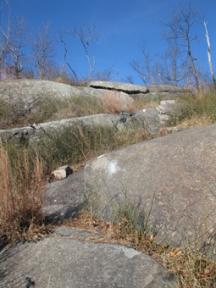 the Wyanokies (1,240 feet), but there are no views from this wooded spot.
In half a mile, the Wyanokie Crest Trail comes out at another east-facing viewpoint over Assiniwikam Mountain, with the view partially obscured by vegetation. It now begins a gradual descent into a broad valley, where it parallels a brook, crossing it several times. The last crossing of the brook is marked by an unusual split boulder. The trail now climbs through a mountain laurel thicket, levels off and continues along undulating terrain. After crossing a woods road (the junction is marked by a cairn), the Wyanokie Crest Trail continues through an area with many fallen trees, then climbs a rocky slope to end at a junction with the red-on-white-blazed Wyanokie Circular Trail and the pink-blazed Will Monroe Loop on a shoulder of Assiniwikam Mountain.
Turn right, following the red-on-white blazes of the Wyanokie Circular Trail, which descends on switchbacks and then climbs a little to cross a rocky woods road. A short distance beyond, it passes to the left of a huge fractured glacial erratic and conti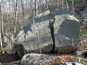 nues to climb past more erratics. After briefly following along the edge of a rocky escarpment, the trail descends to a woods road – the route of the light-green-blazed Otter Hole Trail.
Turn right at the junction (marked by a cairn) and follow the Otter Hole Trail, which goes through a valley and continues past dense mountain laurel thickets. In three-quarters of a mile, you’ll reach a rock outcrop to the right of the trail that offers views across a valley towards Buck Mountain. A short distance beyond, you’ll arrive at a junction with the yellow-blazed Wyanokie Crest Trail. Continue ahead, now retracing your steps. When the Otter Hole Trail ends at a junction with the blue-blazed Hewitt-Butler Trail, turn right, cross Posts Brook, and follow the blue-blazed trail back to the parking area where the hike began.
Publication: Submitted by Daniel Chazin on 09/11/2003 updated/verified on 11/25/2013

This loop hike climbs to several expansive viewpoints on Buck Mountain and returns along a pleasant woods road.
41.045837, -74.350383
Passaic Co., NJ
5 mi
3 hrs

Avenza App Map: Northern New Jersey Highlands 151
Hike Checklist:
Whether you are going for a day hike or backpacking overnight, it is good practice to carry what we call The Hiking Essentials. These essentials will help you enjoy your outing more and will provide basic safety gear if needed. There may also be more essentials, depending on the season and your needs.
The Essentials
Hiking Shoes or Boots
Water - Two quarts per person is recommended in every season. Keep in mind that fluid loss is heightened in winter as well as summer. Don't put yourself in the position of having to end your hike early because you have run out of water.
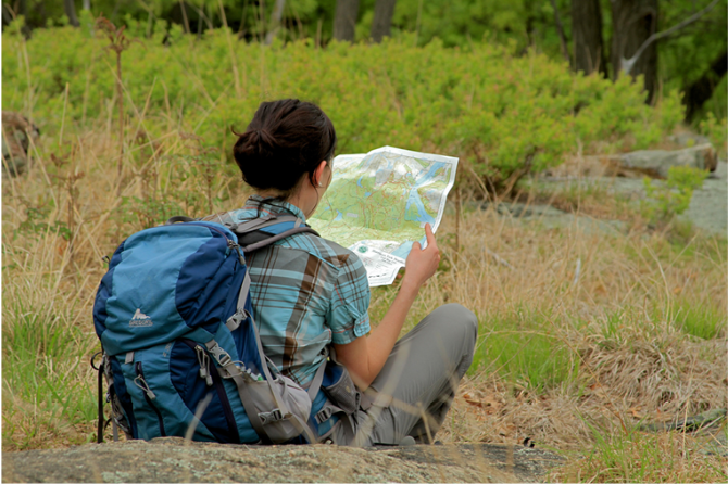
Map - Know where you are and where you are going. Many of our hiking areas feature interconnecting network of trails. Use a waterproof/tear-resistant Tyvek Trail Conference map if available or enclose your map in a Ziplock plastic bag. If you have a mobile device, download Avenza’s free PDF Maps app and grab some GPS-enhanced Trail Conference maps (a backup Tyvek or paper version of the map is good to have just in case your batteries die or you don't have service). Check out some map-reading basics here.
Food - Snacks/lunch will keep you going as you burn energy walking or climbing. Nuts, seeds, and chocolate are favorites on the trail.
Sunscreen and insect repellent
Rain Gear and Extra Clothing - Rain happens. So does cold. Be prepared for changing weather. Avoid cotton--it traps water against your skin and is slow to dry. If you are wearing wet cotton and must return to your starting point, you risk getting chills that may lead to a dangerous hypothermia. Choose synthetic shirts, sweaters and/or vests and dress in layers for easy on and off.
Compass - A simple compass is all you need to orient you and your map to magnetic north.
Light - A flashlight or small, lightweight headlamp will be welcome gear if you find yourself still on the trail when darkness falls. Check the batteries before you start out and have extras in your pack.
First Aid Kit - Keep it simple, compact, and weatherproof. Know how to use the basic components.
Firestarter and Matches - In an emergency, you may need to keep yourself or someone else warm until help arrives. A firestarter (this could be as simple as leftover birthday candles that are kept inside a waterproof container) and matches (again, make sure to keep them in a waterproof container) could save a life.
Knife or Multi-tool - You may need to cut a piece of moleskin to put over a blister, repair a piece of broken equipment, or solve some other unexpected problem.
Emergency Numbers - Know the emergency numbers for the area you're going to and realize that in many locations--especially mountainous ones, your phone will not get reception.
Common Sense - Pay attention to your environment, your energy, and the condition of your companions. Has the weather turned rainy? Is daylight fading? Did you drink all your water? Did your companion fail to bring rain gear? Are you getting tired? Keep in mind that until you turn around you are (typically) only half-way to completing your hike--you must still get back to where you started from! (Exceptions are loop hikes.)
Check the weather forecast before you head out. Know the rules and regulations of the area.
The Leave No Trace Seven Principles
Plan Ahead and Prepare
- Know the regulations and special concerns for the area you'll visit.
- Prepare for extreme weather, hazards, and emergencies.
- Schedule your trip to avoid times of high use.
- Visit in small groups when possible. Consider splitting larger groups into smaller groups.
- Repackage food to minimize waste.
- Use a map and compass to eliminate the use of marking paint, rock cairns or flagging.
Travel and Camp on Durable Surfaces
- Durable surfaces include established trails and campsites, rock, gravel, dry grasses or snow.
- Protect riparian areas by camping at least 200 feet from lakes and streams.
- Good campsites are found, not made. Altering a site is not necessary.
- In popular areas:
- Concentrate use on existing trails and campsites.
- Walk single file in the middle of the trail, even when wet or muddy.
- Keep campsites small. Focus activity in areas where vegetation is absent.
- In pristine areas:
- Disperse use to prevent the creation of campsites and trails.
- Avoid places where impacts are just beginning.
- Pack it in, pack it out. Inspect your campsite and rest areas for trash or spilled foods. Pack out all trash, leftover food and litter.
- Deposit solid human waste in catholes dug 6 to 8 inches deep, at least 200 feet from water, camp and trails. Cover and disguise the cathole when finished.
- Pack out toilet paper and hygiene products.
- To wash yourself or your dishes, carry water 200 feet away from streams or lakes and use small amounts of biodegradable soap. Scatter strained dishwater.
- Preserve the past: examine, but do not touch cultural or historic structures and artifacts.
- Leave rocks, plants and other natural objects as you find them.
- Avoid introducing or transporting non-native species.
- Do not build structures, furniture, or dig trenches.
- Campfires can cause lasting impacts to the backcountry. Use a lightweight stove for cooking and enjoy a candle lantern for light.
- Where fires are permitted, use established fire rings, fire pans, or mound fires.
- Keep fires small. Only use sticks from the ground that can be broken by hand.
- Burn all wood and coals to ash, put out campfires completely, then scatter cool ashes.
- Observe wildlife from a distance. Do not follow or approach them.
- Never feed animals. Feeding wildlife damages their health, alters natural behaviors, and exposes them to predators and other dangers.
- Protect wildlife and your food by storing rations and trash securely.
- Control pets at all times, or leave them at home.
- Avoid wildlife during sensitive times: mating, nesting, raising young, or winter.
Be Considerate of Other Visitors
- Respect other visitors and protect the quality of their experience.
- Be courteous. Yield to other users on the trail.
- Step to the downhill side of the trail when encountering pack stock.
- Take breaks and camp away from trails and other visitors.
- Let nature's sounds prevail. Avoid loud voices and noises.
The Trail Conference is a 2015 Leave No Trace partner.
(c) Leave No Trace Center for Outdoor Ethics: www.LNT.org.
Directions to Trailhead :
Take I-287 to Exit 53 (Bloomingdale) and turn left at the bottom of the ramp onto Hamburg Turnpike. Upon entering Bloomingdale, the name of the road changes to Main Street. In 1.3 miles (from I-287), you will reach a fork in the road. Bear right, and in another 0.1 mile, turn right (uphill) onto Glenwild Avenue, following the sign to West Milford. Continue ahead for 3.2 miles to a parking area on the right side of the road.
TRAIN TRANSPORT :
Not availableBUS TRANSPORT :
Not availableShare Your Experience
SUPPORT
 Support the trails with a donation!
Trail Conference volunteers maintain trails in this hike.
Trip Reports
rate experience June 16, 2020
Fun hike for a family
This hike took us the prescribed 3 hours (with 2 snack breaks!) but our Apple watch said it was 5 miles, not 4, for those who are interested. The first 3rd of the hike is more in the strenuous side of things with a very steep climb up the mountain. We had a group that ranged from 7 to 60 and all of us enjoyed it and were able to complete it. The first third had the most views as well as stepping across the rocks on the stream which is fun for kids especially and the latter two thirds involves traveling through the forest in different terrains(we went in the summer so the brooks were more dried up). Without the perfect turn-by-turn instructions here we would've been struggling so I am very grateful for this clear description. (Only note: When you are leaving the Red-and-White circle trail the description says "marked by a large cairn", it is a cairn but not particularly large just a pile of intentional rocks!) Strong recommend on this hike!
June 26, 2016
Great Hike
<p>Good hike, good directions. Just 2 comments....it sure seemed more than 4.1 miles ....and the one rock climb is a little tough for us octogenarians!</p>
June 22, 2016
Lovely hike!
<p>I enjoyed that we had the entire trail to ourselves and being that it was very well marked, I would recommend it to anyone that is not afraid of a climbing up some big rocks. You do get rewarded after climbing these rocks with magnificent views!</p>