Goosepond Mountain State Park


Park Overview:
The pastoral park is undeveloped except for an abandoned paved road crisscrossed with a labyrinth of unmarked narrow trails. A section of the Highlands Trail traverses it as the only blazed trail.
Park Description:
Largely undeveloped, this is a beautiful park with a mixture of woods, open fields and wetlands amid the hills and valleys of Orange County. The land was originally acquired with funds from the New York Bond Acts of 1960 and 1962. All existing structures were removed to create this expansive recreation area, which has since been returning to its natural state.
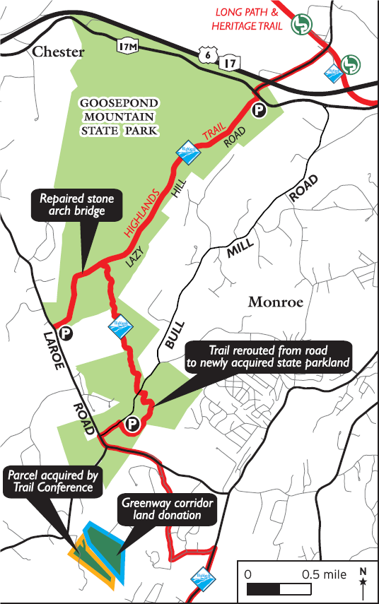
In 2016 the Open Space Institute acquired a 400-acre section near the southern end of the park. Together with Trail Conference volunteers they constructed a small parking area along Bull Mill Road, and assisted in the realignment of the Highlands Trail. In 2018 the new acreage was formally added to Goosepond Mountain State Park under the jurisdiction of the Palisades Interstate Parks Commission (PIPC)
It is located about six miles north of commodity-heavy Woodbury Common "premium outlet mall" and might prove to be the quiet respite needed before the ride home – or a place for a hiker to enjoy nature while the family shops down the road.
Trails Overview:
Like a backbone, the once paved Lazy Hill Road, now converted to a hiking trail, spans the original parkland for 2.6 miles from near the intersection of Craigville Road (CR 51) and NY-17M southwest to Laroe Road (CR 45), where the pathway ultimately becomes narrower.
The Highlands Trail (teal blaze) follows a 1.8-mile segment of Lazy Hill Road from NY 17M southwest into the park. In 2018 the trail was rerouted south (left) at this point, becoming a spur to a parking area on Bull Mill Road. The new two-mile section is a well-graded multi-use trail built for use by hikers and non-motorized bikes. The changed configuration avoids a precarious walk for through hikers along Laroe Road. For more information see NY/NJ Trail Walker, Spring 2018, p.16, which includes an updated trail map.
A confusing maze of un-blazed trails, more like narrow bike paths, cross over the original pathway. Watch out for bikers. Sporadically an orange blaze (always this color) in the form of an arrow points out one of these side paths; it would be easy to become lost by following one without a GPS and compass. It's best as a linear out-and-back hike.
Along Lazy Hill Road there are pleasing views of open fields, rolling hills and, off in the distance, Goose Pond Mountain with an elevation of 1061 feet. This is also a great place to hike on a hot summer day since nearly the entire length is under a canopy of roadside trees.
A previously washed out stone arch bridge over Seely Brook, near the southwest end of Lazy Hill Road, was restored in 2018.
A few reminders of past residents include what was clearly a grand stair step entrance to a house (very close to the only “T” intersection of paved roads), an easily missed sign pointing out a path through a field to the “Board Family Cemetery,” dry-stone boundary walls, and stretches of barbed wire. A few cutoff tops of utility poles remain scattered about at the side of the road.
A separate Nature Trail goes into and around a 5-acre “compensatory mitigation wetlands” a little further north off NY-17M (click to view NYSparks trail map including an insert of the area). It is part of a 108-acre state regulated wetlands serving as a flood plain for Seely Brook. It includes a section of boardwalk above the swamps and is a quiet, beautiful spot with plenty of bird sounds and long, wide vistas of the flood plain. A section of the two-loop trail, which is under a half-mile, passes by a small bottomland hardwood forest. There is no place simply to sit comfortably and enjoy the sounds and views. Small little benches are scattered about, but they are more like low wobbly footstools.
Use the Web Map link on this site to view a trail map including the 2018 re-routed Highlands Trail.
Park Acreage:
1958.00 acresMunicipality:
ChesterThe pastoral park is undeveloped except for an abandoned paved road crisscrossed with a labyrinth of unmarked narrow trails. A section of the Highlands Trail traverses it as the only blazed trail.
Largely undeveloped, this is a beautiful park with a mixture of woods, open fields and wetlands amid the hills and valleys of Orange County. The land was originally acquired with funds from the New York Bond Acts of 1960 and 1962. All existing structures were removed to create this expansive recreation area, which has since been returning to its natural state.
In 2016 the ...
Park Acreage:
1958.00 acresMunicipality:
ChesterContact Information
Web Link:
OPRHP, Goosepond Mountain State ParkPhone:
(845) 786-2701Fees:
NoneDogs in park:
Dogs on leash
Hike Checklist:
Whether you are going for a day hike or backpacking overnight, it is good practice to carry what we call The Hiking Essentials. These essentials will help you enjoy your outing more and will provide basic safety gear if needed. There may also be more essentials, depending on the season and your needs.
The Essentials
Hiking Shoes or Boots
Water - Two quarts per person is recommended in every season. Keep in mind that fluid loss is heightened in winter as well as summer. Don't put yourself in the position of having to end your hike early because you have run out of water.
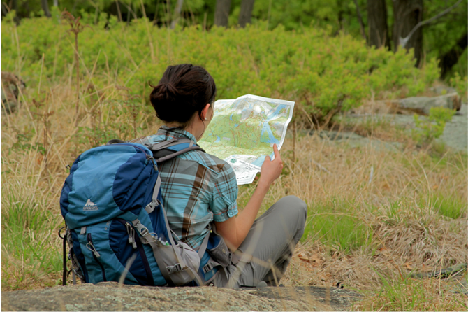
Map - Know where you are and where you are going. Many of our hiking areas feature interconnecting network of trails. Use a waterproof/tear-resistant Tyvek Trail Conference map if available or enclose your map in a Ziplock plastic bag. If you have a mobile device, download Avenza’s free PDF Maps app and grab some GPS-enhanced Trail Conference maps (a backup Tyvek or paper version of the map is good to have just in case your batteries die or you don't have service). Check out some map-reading basics here.
Food - Snacks/lunch will keep you going as you burn energy walking or climbing. Nuts, seeds, and chocolate are favorites on the trail.
Sunscreen and insect repellent
Rain Gear and Extra Clothing - Rain happens. So does cold. Be prepared for changing weather. Avoid cotton--it traps water against your skin and is slow to dry. If you are wearing wet cotton and must return to your starting point, you risk getting chills that may lead to a dangerous hypothermia. Choose synthetic shirts, sweaters and/or vests and dress in layers for easy on and off.
Compass - A simple compass is all you need to orient you and your map to magnetic north.
Light - A flashlight or small, lightweight headlamp will be welcome gear if you find yourself still on the trail when darkness falls. Check the batteries before you start out and have extras in your pack.
First Aid Kit - Keep it simple, compact, and weatherproof. Know how to use the basic components.
Firestarter and Matches - In an emergency, you may need to keep yourself or someone else warm until help arrives. A firestarter (this could be as simple as leftover birthday candles that are kept inside a waterproof container) and matches (again, make sure to keep them in a waterproof container) could save a life.
Knife or Multi-tool - You may need to cut a piece of moleskin to put over a blister, repair a piece of broken equipment, or solve some other unexpected problem.
Emergency Numbers - Know the emergency numbers for the area you're going to and realize that in many locations--especially mountainous ones, your phone will not get reception.
Common Sense - Pay attention to your environment, your energy, and the condition of your companions. Has the weather turned rainy? Is daylight fading? Did you drink all your water? Did your companion fail to bring rain gear? Are you getting tired? Keep in mind that until you turn around you are (typically) only half-way to completing your hike--you must still get back to where you started from! (Exceptions are loop hikes.)
Check the weather forecast before you head out. Know the rules and regulations of the area.
The Leave No Trace Seven Principles
Plan Ahead and Prepare
- Know the regulations and special concerns for the area you'll visit.
- Prepare for extreme weather, hazards, and emergencies.
- Schedule your trip to avoid times of high use.
- Visit in small groups when possible. Consider splitting larger groups into smaller groups.
- Repackage food to minimize waste.
- Use a map and compass to eliminate the use of marking paint, rock cairns or flagging.
Travel and Camp on Durable Surfaces
- Durable surfaces include established trails and campsites, rock, gravel, dry grasses or snow.
- Protect riparian areas by camping at least 200 feet from lakes and streams.
- Good campsites are found, not made. Altering a site is not necessary.
- In popular areas:
- Concentrate use on existing trails and campsites.
- Walk single file in the middle of the trail, even when wet or muddy.
- Keep campsites small. Focus activity in areas where vegetation is absent.
- In pristine areas:
- Disperse use to prevent the creation of campsites and trails.
- Avoid places where impacts are just beginning.
- Pack it in, pack it out. Inspect your campsite and rest areas for trash or spilled foods. Pack out all trash, leftover food and litter.
- Deposit solid human waste in catholes dug 6 to 8 inches deep, at least 200 feet from water, camp and trails. Cover and disguise the cathole when finished.
- Pack out toilet paper and hygiene products.
- To wash yourself or your dishes, carry water 200 feet away from streams or lakes and use small amounts of biodegradable soap. Scatter strained dishwater.
- Preserve the past: examine, but do not touch cultural or historic structures and artifacts.
- Leave rocks, plants and other natural objects as you find them.
- Avoid introducing or transporting non-native species.
- Do not build structures, furniture, or dig trenches.
- Campfires can cause lasting impacts to the backcountry. Use a lightweight stove for cooking and enjoy a candle lantern for light.
- Where fires are permitted, use established fire rings, fire pans, or mound fires.
- Keep fires small. Only use sticks from the ground that can be broken by hand.
- Burn all wood and coals to ash, put out campfires completely, then scatter cool ashes.
- Observe wildlife from a distance. Do not follow or approach them.
- Never feed animals. Feeding wildlife damages their health, alters natural behaviors, and exposes them to predators and other dangers.
- Protect wildlife and your food by storing rations and trash securely.
- Control pets at all times, or leave them at home.
- Avoid wildlife during sensitive times: mating, nesting, raising young, or winter.
Be Considerate of Other Visitors
- Respect other visitors and protect the quality of their experience.
- Be courteous. Yield to other users on the trail.
- Step to the downhill side of the trail when encountering pack stock.
- Take breaks and camp away from trails and other visitors.
- Let nature's sounds prevail. Avoid loud voices and noises.
The Trail Conference is a 2015 Leave No Trace partner.
(c) Leave No Trace Center for Outdoor Ethics: www.LNT.org.
Directions to Trailhead :
From the NYS Thruway, take exit 16 to NY-17 West (also US-6 West ). In about 5 miles take exit 128 for County Road 51 toward Oxford Depot, turn right onto CR 51 follow it 0.3-mile to a stop sign at NY-17M
- Lazy Hill Road trailhead parking area: Turn left on NY-17M, a large parking area is immediately on your left – it has two entrances if you miss the first turn-off. The trailhead, with a steel rope blocking vehicular traffic, is across the roadway. GPS Coordinates: 41.345678, -74.226142
- Nature Trail parking area: Turn right on onto NY-17M. In about a minute a small parking area will be on the left. GPS Coordinates: 41.348400,-74.234467
- Laroe Road parking area (not recommended): Parking is also available off Laroe Road along the southwest border of the park. It may hold only four cars, since blocking the access gate is prohibited. Turn left onto NY-17M, travel 0.6 mile to Bull Mill Road, turn right. Follow the curving road 3.3 miles to a “T” at Laroe Road (CR 45). Turn right, travel 1.0 mile to turnout on the right before reaching Spruce Hill Road up on the left. As a warning to slow down, a “45 MPH” speed limit sign is just before the parking area. GPS Coordinates: 41.319140, -74.257965
- Bull Mill Road parking: Newly created trailhead in 2018, follow instructions from NY 17M to Laroe Road above. Along Bull Mill Road before reaching Laroe Road parking area is on the left. Approximate GPS Coordinates: 41.309280, -74.245899
TRAIN TRANSPORT :
Not availableBUS TRANSPORT :
Not availableShare Your Experience
 Support the trails with a donation!