Ramapo Valley County Reservation


Park Overview:
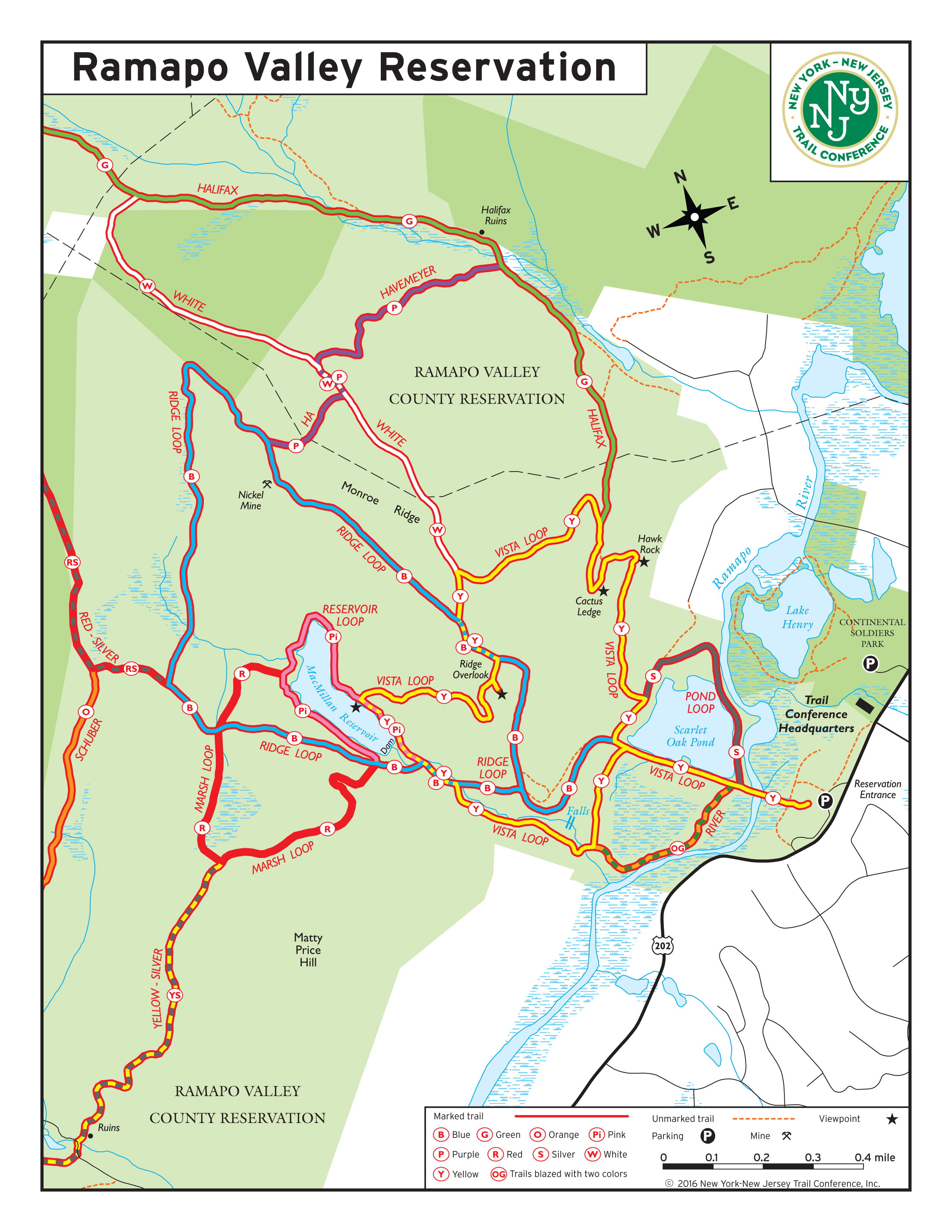
The park features a network of five loop trails, all beginning within a two-mile radius of the parking lot. The Vista Loop Trail (yellow blaze) includes three panoramic views, a pond, a reservoir and a waterfall. The park is a popular destination for dog walking.
Park Description:
“The Reservation,” located in Mahwah, is a popular Bergen County Park. Many visitors walk around Scarlet Oak Pond, a former gravel quarry, or climb on a wide, smooth-surface road to MacMillan Reservoir (which once supplied the Crocker Mansion on the far side of Ramapo Valley Road). It is a favorite of dog owners who exercise their pets.
Ramapo Valley Reservation also offers challenging hiking. Outside the commonly used core area, the parkland has been left in its natural -- mostly hilly and rocky -- wild state, forming part of the eastern tier of the Ramapo Mountains. Several of its trails connect with those in Ringwood State Park to the west, Ramapo Mountain State Forest to the southwest, and Camp Glen Gray to the south, making possible a wide variety of rugged day-long hikes. One example, the Schuber Trail (orange; 4.7 miles + 1.8 miles from parking lot), passes through Camp Glen Gray and continues to its southern terminus at Skyline Drive.
Fishing is permitted with a valid NJ fishing license.
Trails Overview:
The newly configured loop trails are:
- Vista Loop (yellow; loop 3.75 miles; trailhead at parking lot; rated “moderate to strenuous”) – Destined to become the Reservation’s signature trail. Hikers can follow a single set of yellow blazes from the parking lot in a counterclockwise direction (recommended) to view three panoramas: Hawk Rock, Cactus Ledge – a spectacular new addition to the trail system -- and Ridge Overlook. Additional park features include Scarlet Oak Pond, MacMillan Reservoir, and MacMillan Brook (and its waterfall). Its "moderate-to-strenuous" rating is due to the steep ascent up to Hawk Rock and Cactus Ledge.
- Click for a detailed description of a hike on this trail.
- Ridge Loop (blue; loop 3.0 miles, total to/from parking lot, 4.25 miles; rated “moderate plus”) – The existing trail to Ridge Overlook and along Monroe Ridge is extended back down to the south end of MacMillan Reservoir to meet Vista Loop Trail. Recommended hiking direction: counterclockwise
- Marsh Loop (red; loop 1.1 miles, total to/from parking lot, 3.5 miles; rated “moderate”) – Begins opposite MacMillan Reservoir dam and loops to rejoin MacMillan Reservoir at its northern end, at an intersection with the Reservoir Loop Trail near Scout bridge. Recommended hiking direction: clockwise
- Reservoir Loop (pink; loop 0.65 mile, total to/from parking lot, 3.0 miles; rated “moderate”) – Existing scenic trail circles most of MacMillan Reservoir. Hike rated moderate due to rocky patches. Recommended hiking direction: clockwise
- Pond Loop (silver; loop 0.9 mile, total to/from parking lot 1.1 miles; rated “easy”) – Combine with segment of Vista Loop Trail (yellow) to circle Scarlet Oak Pond. Wide, hard-packed sand roadway that can be navigated with strollers.
Related changes:
- River Trail (orange/green dot, designed “OG” on revised trail map, 0.4 mile) – New trail name, incorporates 0.4 mile segment of former Schuber Trail running southwest along the Ramapo River.
- Schuber Trail (orange) – now begins 1.8 miles from parking lot. To reach the trailhead: Vista Loop Trail (yellow) to Ridge Loop Trail (blue) clockwise to the west of MacMillan Reservoir to Red-Silver Trail, proceed just over 0.1 mile further, make sharp left to head south on Schuber Trail.
- Havemeyer Trail – blazing changed from blue/white to purple to eliminate confusion with blue Ridge Loop Trail.
- Silver Trail – no longer blazed from parking lot; see Pond Loop Trail
- Halifax Trail (green) now begins north of Cactus Ledge (along Vista Loop Trail)
- Yellow/Silver Trail now begins off Marsh Loop Trail, 0.5 mile from MacMillan Reservoir dam.
Beyond the Reservation’s “core” recreation area around Scarlet Oak Pond/ MacMillan Reservoir is an extended network of trails both within the park and connecting to other public lands. Use Web Map link near top of page. To view full descriptions of hikes in the Reservation, click here. Photographs taken along a Vista Loop hike may be seen here (October 2016).
Park Acreage:
4290.00 acresMunicipality:
MahwahThe park features a network of five loop trails, all beginning within a two-mile radius of the parking lot. The Vista Loop Trail (yellow blaze) includes three panoramic views, a pond, a reservoir and a waterfall. The park is a popular destination for dog walking.
“The Reservation,” located in Mahwah, is a popular Bergen County Park. Many visitors walk around Scarlet Oak Pond, a former gravel quarry, or climb on a wide, smooth-surface road to MacMillan Reservoir (which once supplied the Crocker Mansion on the far side of Ramapo Valley Road). It is a favorite of dog owners who exercise their pets.
Ramapo Valley Reservation also offers...
Park Acreage:
4290.00 acresMunicipality:
MahwahContact Information
Web Link:
Bergen County Department of ParksPhone:
(201) 336-7275Fees:
NoneDogs in park:
Dogs on leash
Hike Checklist:
Whether you are going for a day hike or backpacking overnight, it is good practice to carry what we call The Hiking Essentials. These essentials will help you enjoy your outing more and will provide basic safety gear if needed. There may also be more essentials, depending on the season and your needs.
The Essentials
Hiking Shoes or Boots
Water - Two quarts per person is recommended in every season. Keep in mind that fluid loss is heightened in winter as well as summer. Don't put yourself in the position of having to end your hike early because you have run out of water.
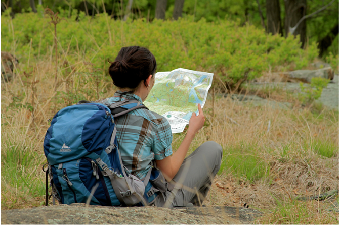
Map - Know where you are and where you are going. Many of our hiking areas feature interconnecting network of trails. Use a waterproof/tear-resistant Tyvek Trail Conference map if available or enclose your map in a Ziplock plastic bag. If you have a mobile device, download Avenza’s free PDF Maps app and grab some GPS-enhanced Trail Conference maps (a backup Tyvek or paper version of the map is good to have just in case your batteries die or you don't have service). Check out some map-reading basics here.
Food - Snacks/lunch will keep you going as you burn energy walking or climbing. Nuts, seeds, and chocolate are favorites on the trail.
Sunscreen and insect repellent
Rain Gear and Extra Clothing - Rain happens. So does cold. Be prepared for changing weather. Avoid cotton--it traps water against your skin and is slow to dry. If you are wearing wet cotton and must return to your starting point, you risk getting chills that may lead to a dangerous hypothermia. Choose synthetic shirts, sweaters and/or vests and dress in layers for easy on and off.
Compass - A simple compass is all you need to orient you and your map to magnetic north.
Light - A flashlight or small, lightweight headlamp will be welcome gear if you find yourself still on the trail when darkness falls. Check the batteries before you start out and have extras in your pack.
First Aid Kit - Keep it simple, compact, and weatherproof. Know how to use the basic components.
Firestarter and Matches - In an emergency, you may need to keep yourself or someone else warm until help arrives. A firestarter (this could be as simple as leftover birthday candles that are kept inside a waterproof container) and matches (again, make sure to keep them in a waterproof container) could save a life.
Knife or Multi-tool - You may need to cut a piece of moleskin to put over a blister, repair a piece of broken equipment, or solve some other unexpected problem.
Emergency Numbers - Know the emergency numbers for the area you're going to and realize that in many locations--especially mountainous ones, your phone will not get reception.
Common Sense - Pay attention to your environment, your energy, and the condition of your companions. Has the weather turned rainy? Is daylight fading? Did you drink all your water? Did your companion fail to bring rain gear? Are you getting tired? Keep in mind that until you turn around you are (typically) only half-way to completing your hike--you must still get back to where you started from! (Exceptions are loop hikes.)
Check the weather forecast before you head out. Know the rules and regulations of the area.
The Leave No Trace Seven Principles
Plan Ahead and Prepare
- Know the regulations and special concerns for the area you'll visit.
- Prepare for extreme weather, hazards, and emergencies.
- Schedule your trip to avoid times of high use.
- Visit in small groups when possible. Consider splitting larger groups into smaller groups.
- Repackage food to minimize waste.
- Use a map and compass to eliminate the use of marking paint, rock cairns or flagging.
Travel and Camp on Durable Surfaces
- Durable surfaces include established trails and campsites, rock, gravel, dry grasses or snow.
- Protect riparian areas by camping at least 200 feet from lakes and streams.
- Good campsites are found, not made. Altering a site is not necessary.
- In popular areas:
- Concentrate use on existing trails and campsites.
- Walk single file in the middle of the trail, even when wet or muddy.
- Keep campsites small. Focus activity in areas where vegetation is absent.
- In pristine areas:
- Disperse use to prevent the creation of campsites and trails.
- Avoid places where impacts are just beginning.
- Pack it in, pack it out. Inspect your campsite and rest areas for trash or spilled foods. Pack out all trash, leftover food and litter.
- Deposit solid human waste in catholes dug 6 to 8 inches deep, at least 200 feet from water, camp and trails. Cover and disguise the cathole when finished.
- Pack out toilet paper and hygiene products.
- To wash yourself or your dishes, carry water 200 feet away from streams or lakes and use small amounts of biodegradable soap. Scatter strained dishwater.
- Preserve the past: examine, but do not touch cultural or historic structures and artifacts.
- Leave rocks, plants and other natural objects as you find them.
- Avoid introducing or transporting non-native species.
- Do not build structures, furniture, or dig trenches.
- Campfires can cause lasting impacts to the backcountry. Use a lightweight stove for cooking and enjoy a candle lantern for light.
- Where fires are permitted, use established fire rings, fire pans, or mound fires.
- Keep fires small. Only use sticks from the ground that can be broken by hand.
- Burn all wood and coals to ash, put out campfires completely, then scatter cool ashes.
- Observe wildlife from a distance. Do not follow or approach them.
- Never feed animals. Feeding wildlife damages their health, alters natural behaviors, and exposes them to predators and other dangers.
- Protect wildlife and your food by storing rations and trash securely.
- Control pets at all times, or leave them at home.
- Avoid wildlife during sensitive times: mating, nesting, raising young, or winter.
Be Considerate of Other Visitors
- Respect other visitors and protect the quality of their experience.
- Be courteous. Yield to other users on the trail.
- Step to the downhill side of the trail when encountering pack stock.
- Take breaks and camp away from trails and other visitors.
- Let nature's sounds prevail. Avoid loud voices and noises.
The Trail Conference is a 2015 Leave No Trace partner.
(c) Leave No Trace Center for Outdoor Ethics: www.LNT.org.
Directions to Trailhead :
From NJ 17 (north or south), near the New York border, exit right to Ramapo Valley Road (US 202) tand urn left (south) at the end of the ramp. Proceed for two miles to the Reservation’s entrance on right. The Trail Conference’s Darlington Schoolhouse Headquarters at Darlington Avenue is 0.1 mile before the park entrance. GPS Coordinates: 41.077886, -74.186052
Parking is rarely a problem during the week. But by mid-day on weekends with good weather, waits may be required for a parking spot to open. Hikers are NOT permitted to park at the nearby church on Darlington Avenue, and parking at the Trail Conference's small parking lot is discouraged. Here are alternatives:
- During spring 2018, a wide paved sidewalk was completed along the west side of Ramapo Valley Road from the nearby Continental Soldiers Field, where parking is available, to the Trail Conference' headquarters. From there, a wide path through the woods leads to the Reservation’s parking area and trailheads.
- The possibility of a quiet, beautiful, even solitary, one-mile hike around Lake Henry at Continental Soldiers Field is an added benefit of parking there.
- On weekends, hiker parking is also permitted at Ramapo College near its South Gate entrance, directly across from Continental Soldiers Field. A traffic light permits the safe crossing of Ramapo Valley Road to the wide sidewalk along the west side of the road.
TRAIN TRANSPORT :
Not availableBUS TRANSPORT :
Short Line offers bus service from Port Authority Bus Terminal in New York City to Ramapo College, which is located about a half mile north of the park entrance on Route 202 (Ramapo Valley Road). Walk through the campus parking lot to the South Gate entrance and a traffic light to cross Route 202.
For schedule information, go to www.shortlinebus.com (use "Mahwah" for destination, click, then select "Ramapo College" ). Limited service is available on weekends.
Share Your Experience
 Support the trails with a donation!
Trip Reports
rate experience- stoppilgrimpipeline
- pilgrim pipeline full steam ahead
- pilgrim pipeline holdings llc project description